| |
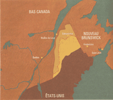
La question de l'appui des États-Unis ŕ la rébellion patriote a beau avoir fait couler beaucoup d'encre, reste qu'on a souvent oublié d'envisager qu'ŕ l'époque, la Grande-Bretagne et les États-Unis entretiennent un contentieux territorial important ŕ propos de la frontičre du Maine avec le Nouveau-Brunswick et le Bas-Canada. Ce problčme sera en partie remédié par le Traité de Washington de 1842 mais est encore la source d'une certaine tention entre les deux États vers 1837. L'article que nous reproduisons ici est d'ailleurs du The Courrier de Saint-Jean (NB), du 28 octobre 1837. Nous le présentons ici ŕ peu prčs intégralement. Il permet en particulier de prendre la mesure de l'importance que pouvait représenter ce problčme dans le contexte des rébellions bas-canadienne.
gl
The treaty runs as follows--"From the north west angle of Nova Scotia, viz. that angle which is formed by a line drawn due north from the source of the St. Croix to the high lands; along the said high lands which divide these rivers which empty themselves into the river St. Lawrence, from those which fall into the Atlantic Ocean to the north westernmost head of the Connecticut River," &c. &c.
It would appear that the misinterpretation on the spirit of the treaty arises from an error in establishing the point of departure for the further demarkation of the boundary line, forming the basis of the treaty, viz. "from the north west angle of Nova Scotia." The treaty proceeds to give an explicit account of its situation, viz. "that angle which is formed by a line drawn due north from the source of the St. Croix to the high lands;" it must be conceded that the high lands here alluded to by British Commissioner, are the first mountainous range arrived at in a northerly direction, which is at a point called Mars Hill, part of the Aros-took range of mountains. This is the "the north west angle of Nova Scotia," and the point of departure for the further demarkation of the boundary line.
The treaty then proceeds to say, "along the said high lands which divide these rivers which empty themselves into the river St. Lawrence, from those which fall into the Atlantic Ocean to &c." By this it appears that the British Commissioner was ignorant that the waters running north of this chain of mountains fall into the St. John River, and ultimately into the Bay of Fundy. But his ignorance of the topography of the country cannot alter the point of departure from "the line drawn due north from the source of the St. Croix to the high lands" or " the north west angle of Nova Scotia." Therefore there can be no doubt that the British Commissioner intended that the boundary line should extend from that point in a Westerly direction upon the ridge of that chain of mountain, until it arrives at the Connecticut River.
By taking into consideration even that part of the Treaty, viz. "said high lands which divide these rivers which empty themselves into the river St. Lawrence, from those which fall into the Atlantic Ocean," it is apparent these high lands can only be discovered at the south easternmost shore of the River Chaudiere in Lower Canada, and the head waters of the Kennebec River in the State of Maine, it being recollected that the River Saint John empties itself into the Bay of Fundy, not into the Atlantic Ocean.
It must then be evident, that (by adhering to the words of the Treaty) were the northern line prolonged beyond the proper point of departure at Mars Hill, it would not traverse any range of mountains separating Rivers flowing on one side into the Atlantic, on the other into the St. Lawrence.
It becomes a question whether the point of departure now claimed by the United States, a few miles south of the River St. Lawrence, formerly a part of Nova Scotia at the time the Treaty was made, the Restigouche River at present forming the Northern Boundary of New Brunswick, which was formerly a part of Nova Scotia. -- perhaps the point of departure should be considered in that light, is the source of the River St. Croix, and not the "north west angle of Nova Scotia," of which (as before mentioned) the subsequent sentence in the treaty explains this position. This may be considered as the fundamental error that many in the British interest have overlooked.
Maugerville, October 4, 1837
SOURCE SECONDAIRE: CanadianHistory
| |